Since 1763 the name 'Russborough' has been synonymous with collecting and dealing in fine art. In the closing decades of the last century the historic town of Port Hope has become home to Lord Russborough's Annex, which specialises in an individual mix of antique maps, paintings and prints.

While Lord Russborough's Annex features a great many works of museum calibre, we also offer a wonderful selection of prints priced at under $100.

Moll North America

An extract of our prints currently available:
MOLL.H. North America-the Cod Fishery Map

One of the great large format maps of North America showing California as an Island

MOLL   NORTH AMERICA

 To the Right Honourable John Lord Sommers
.... [Baron of Evesham in the county of Worcester President of her Majesty's most honourable Privy Council & c.]
 This Map of  NORTH AMERICA according to the newest and most exact observations ....... [is most humbly dedicated by your Lordship's most humble servant]  Hermann Moll geographer.

Printed for J & T Bowles, P. Overton and J. King. London [Ca.1720]
Original Copper engraved map hand tinted in outline colour. Printed on two sheets, joined as issued. Some light age browning along folds. Size: 22 7/8 x 38" (58.1 x96.5 cm)   Matted to museum standard. glazed and handsomely set in a black & silver-gilt wood frame. Frame Size: 32 1/2 x 47 1/4"

Ref. PR1/LNNN / g.ando> VLNN     PRICE CODE  I  SOLD

Published in Moll, Herman. The world described, or a new and correct sett of maps. [London: J. Bowles, Maps separately published 1709-1720 as a folio in different editions 1715-1754 contemporary hand colouring 1s extra]. Plate 7. 1720

Political posturing was arguably the reason Moll's map of North America was published. It being a response to De l’Isle's influential map Carte de La Louisiane de du Cours du Mississipi of 1718, in which De l’Isle emphasized the French claim to the Carolinas.  Moll and the British hoped to counter those claims with the publication of this map, which depicts Newfoundland through the Carolinas under British control and extends British claims to Labrador (New Britain) and the area surrounding Hudson's Bay. Further, Moll reduces France's claim in Louisiana which here extends south of the Ouabach ou de S. Jerome (Ohio) River (with the interesting note "the road usually taken from Carolina to Canada is by this river.") and west to the North River (Rio Bravo del Norte/Rio Grande). 
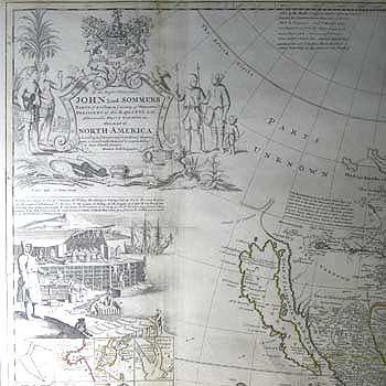
An elaborate title vignette engraved by G. Vertue after a drawing by B. Lens is surmounted by the Sommers Coat of Arms, (Sommers was an English Whig jurist and statesman who is known for his role in the Bill of Rights in 1689).  Also depicts an Eskimo family holding spears and bow, with another in a kayak to the rear. To the left, a pair of scantily clad southern Indians, the female of which holds a trade-good mirror. The male a bow, with two rolled mats under his arm. In the background is a parrot, stooks of corn, date palm and a farmer harvesting tobacco. Below, reclines another tattooed Indian warrior holding a scalp and bow, he reclines amid the bounty of the country: sugar cane, maize, rattan mats, pot of gold coin, bars of silver and tobacco plant.

Moll codFishery map title

Below and to the left is another keyed engraving depicting a view of a stage & also of ye manner of fishing for, curing & drying cod at Newfoundland. Hence its popular moniker 'Cod Fish Map'The Cod Fishery was largest source of wealth from North America at the time, rivalled only by Virginia's tobacco crop and plundered Spanish treasure.

Below that, are ten inset delineations of coastal harbours: “St. John's Harbour," "Boston Harbour," "New York," "Ashley & Cooper River,""Port Royal Harbour," "The Bay & Cay of ye Havana," "The Bay of Pto. Bella,"  "La Vera Cruz", "Cartagena Harbour and Forts," and "The Port of Acapulco." 

Bottom Right is an explanation of the engraved trade winds taken from the maps of Sir Edmund Halley (1656-1742). Moll, a friend of Halley, was well aware of the significance of the trade winds to both legitimate trade and piracy. Shown are the tracks of the Spanish treasure galleons or 'Flota' to Cartegena and Havana. These highly prized ships (especially by English Privateers & Buccaneers, a number of the latter with whom Moll was well acquainted, hence the delineation of the potential areas for piracy) returned to Spain most years laden with Aztec gold and North American Silver and gemstones.   Also to the right is a note regarding French Name changes to 1714.


Of the Map itself which delineates the area from California east to the Spanish Main, North to the early 18th. century known areas of America and the Arctic and across the Western (Atlantic) Ocean to Greenland, Iceland and Ireland. There are many points of cartographical interest, the principle one being the depiction of California as an Island. Based on the second Sanson (1656) variant with an indented top, but with a number of added names Mounts Navada & St Martin, P.de Sardines and four towns in the south La Conception, St. Nicholas, St Isidore and Gigante.  (Tooley)

In the Arctic, the outline of Baffin's Bay has yet to be determined, alternative delineations being given. The tracks of the voyages of Hudson & James are shown. The Great lakes are delineated after Coronelli 1695 - Frontenac (Ontario); Lahonton 1703 - Errie (Erie) & Huron; Moll 1720-  Ilinese (Michigan) & Upper Lake (Superior). To the west of the Mississippi stretches the chain of Lakes and 'Longue river of the west' described by the Baron Louis Armand Lahonton with an explanatory note. His dubious 1690 'waterway discoveries' were incorporated into the maps of most of the leading cartographers of the day. In Southern Ontario, Ganaraske Bay and Ganeous (Port Hope) are shown. Seven US territories are named with Louisiana incorporating Florida. Also named, are the New Albion of Sir Francis Drake (Discovered 1578) and the apocryphal Straits of Anian (Allegedly discovered 1706). Numerous indigenous Indian tribal areas and settlements are also named. In all, this is one of the great classic maps of North America, containing a wealth of fascinating information, to grace the wall of a map connoisseur. 

Vide: Tooley R.V. Mapping of America : California as an Island #82  The Holland Press.London 1980.
          Goss (NA) #53; Schwartz & Ehrenberg p.140, pl.79; McLaughlin #192; Wheat (TMW) #105.
Herman Moll (c. 1654-1732) was one of the most important London mapmakers in the first half of the eighteenth century.  Moll was probably born in Bremen, Germany, around 1654. He moved to London to escape the Scanian Wars. His earliest work was as an engraver for Moses Pitt on the production of the English Atlas, a failed work which landed Pitt in debtor's prison. Moll also engraved for Robert Morden, Philip Lea, Sir Jonas Moore, Grenville Collins, John Adair, and the Seller & Price firm. He published his first original maps in the early 1680s and had set up his own shop by the 1690s.  An early publication in his own name to feature his maps was A System of Geography (1701).
This was followed by Fifty-six new and accurate maps of Great Britain (1708) and the Atlas Geographus (1708-17). His greatest masterpiece, The World Described (1715-20), contained 30 large maps. Highlights of the atlas included the "Codfish Map" and the "Beaver Map" editions ran until 1754.
Moll's work quickly helped him become a member of a group which congregated at Jonathan's Coffee House at Number 20 Exchange Alley, Cornhill, where speculators met to trade stock. Moll's circle included the scientists Robert Hooke, and Sir Edmund Halley, the archaeologist William Stuckley, the authors Jonathan Swift and Daniel Defoe, and the intellectually-gifted pirates William Dampier, Woodes Rogers and William Hacke. From these contacts, Moll gained a great deal of privileged information that was included in his maps giving them a unique attraction, such as this fine example. 
He also frequently made maps for books, including those of Dampier’s publications and Swift’s Gulliver’s Travels. Moll died in 1732. It is likely that his plates passed to another contemporary, Thomas Bowles, after this death.